The Rutgers Marine Field Station rises on weathered pilings overlooking a fragile wetland, surrounded by a sea of tall salt grass brushed here and there into sweeping hypnotic patterns by the wind. White herring gulls dot the brown marsh as they stand over dark, brackish tidal pools, hunting for fiddler crabs.
Ten years ago, this was Ground Zero for Superstorm Sandy, which roared over the inlet when it made landfall in New Jersey.
Today, the estuary around the remote research facility in Little Egg Harbor is mostly healed. Yet the ecology of the marsh itself has changed, in response to the rising global temperatures attributed to climate change that many believe is likely to spawn more and even deadlier storms than Sandy and now Hurricane Ian, which only recently devastated Florida.
In a place between the land and the sea, researchers are studying those changes. They collect the larvae that floats in with the tide. They keep track of visitors who arrive by air or by sea, and watch the day-to-day life cycle amid the tidal pools left behind when the water recedes, and in the spartina reeds at water’s edge. The field station serves as a window — not only on the impact of climate change, but on just how the next big storm to hit New Jersey might behave.

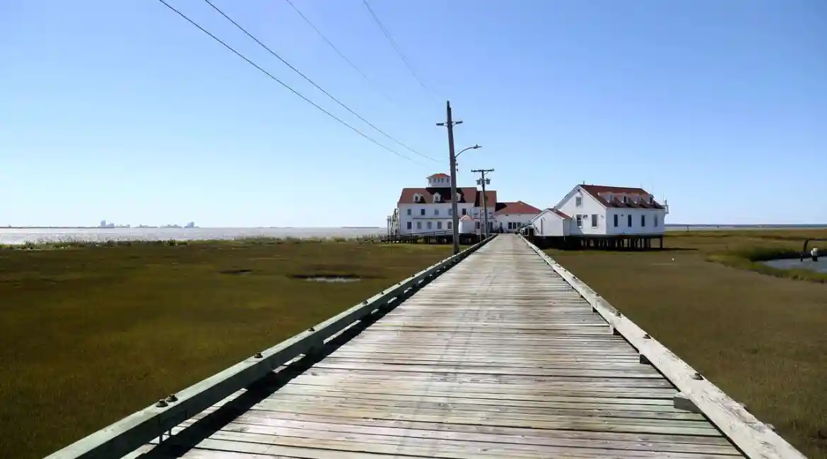
The road to the station begins down in Tuckerton and involves a seven-mile-long drive across uninhabited islands and mudflats, over one-lane bridges where fishermen cast their lines, past isolated marinas and then finally to a dead end on the Mullica Hill Estuary where the white buildings capped with red roofs finally make their appearance in the distance. The road is not always passable. High tide sometimes will flood the pavement several times a month, even on sunny days.
A walk from the road across a wooden causeway elevated over the marsh finally brings you to Roland Hagan, who came here as an intern in 1989 and now serves as operations manager for the Rutgers lab that has been studying the estuary for the past 50 years.
“I make sure the place doesn’t fall apart,” he laughed, before setting off on a tour of the station, from the “clean labs” that are always dirty because no cleaning chemicals are allowed in the room for fear of contaminating samples, to the observation cupola high atop the station that offers a panoramic view of the wetlands.

Perched above the water, the lab is “like a boat on stilts,” observed Hagan. Wastewater is collected in holding tanks and pumped out each week so as not to disturb the environment they study every day. Inside are samples of fish and crab larvae collected by researchers and students. Sensors in the water track the passage of marine life. One ongoing study involves documenting the spread of microplastics in fish.
He pointed offshore to a pelican, once a rare guest from warmer waters, gliding just offshore, diving and coming up with its lunch. “They don’t like the cold airOr much,” Hagan noted.
With the changes in climate, there has been a dramatic shift in the kinds of fish being seen around the station, including more species from south of Cape Hatteras, and fewer from the north of Cape Cod, according to Oscar Schofield, chairman of Rutgers’ Department of Marine and Coastal Sciences.
“Different fish have been moving into the estuary because the ocean is getting warmer,” he said.
And higher water temperatures are not the only changes in the estuary. The sea level rise here is occurring faster than anywhere else in the world, Schofield noted, in part because the South Jersey coastline continues to sink; a legacy of the geology left behind by the last ice age.
That could spell even more flooding problems for Atlantic City, which can be seen off in the distance, sometimes casting a hellish red glow in the night sky when the clouds are low. Some studies suggest half of the gaming resort could be uninhabitable by 2060.
As part of its research, the station deploys a fleet of underwater drones as well — sometimes to track marine life, and at times to collect data on hurricanes.
On the evening before Sandy came ashore, one such drone carrying the designation of RU-23 was already radioing back data about the storm. Launched into the ocean four days earlier by a Rutgers team led by researcher Travis Miles, now an assistant professor at the university, its mission was to collect information about currents and water temperatures, even as the seas roiled.
The yellow, sensor-laden torpedo-like robotic craft, known as a Slocum Glider (named for Joshua Slocum, the first man to single-handedly sail around the world), is a unique research tool. It has no propeller, using its ability to rise and sink deep into the ocean to navigate by “flying” through the water in a series of dives. Using minimal power, it can operate for weeks, sinking and gliding, and then rising towards the surface, over and over again.
As the storm raced toward the New Jersey coast, Schofield was able to keep tabs on the data being uploaded by RU-23, seeing what was happening in the middle of Sandy in real time from more than 100 miles away.

“We were shutting down for the evening and getting out of Dodge and checking on in-laws. It all had this post-apocalyptic feel,” he said, thinking back to the storm 10 years earlier. “But we were getting data because the robot was right in the heart of the storm at sea.”
A similar deployment of a drone during Hurricane Irene a year earlier had provided researchers with their first “eureka” moment, he said. Hurricanes get their energy from the ocean, acting as a “fuel can” for the storm. The warmer the water, the more fuel for the hurricane. Weather satellites can detect surface water temperatures, allowing forecasters to predict a hurricane’s likely intensity.
But the ocean is essentially not unlike a multi-layer cocktail, defined not by stacked liquors, as in a pousse-café, but by different water temperatures at different depths, unseen by the satellites. The Rutgers drone gliding silently through those layers noted a dramatic change in ocean temperature was occurring. It found during Irene that the different water layers began mixing as the hurricane approached, rapidly dropping the surface temperature — cutting off the hurricane’s fuel supply and causing major changes in its intensity.
The deployment of RU-23 during Sandy once again recorded similar change in temperatures.
Sitting at home, Schofield watched from his computer as the data come in, as if transmitted from another planet. “Look at the ocean!” he recalled exclaiming to a colleague as they both monitored the data. “It just did that.”
That research, he said, has given forecasters far greater insight into the science of hurricane forecasting and to their ability to predict intensity.
That’s exciting to him.
“We’re on the cusp of having a new way of reacting to those storms ahead of time,” Schofield said. “We got the atmosphere. But we never got the ocean right. It’s led to a new resurgence of new approaches, so we can tell not only where the storm is coming, but its intensity. That influences whether we do a stay in place or evacuation order. If you don’t get intensity right, you can’t get surge right.”
The approach of Sandy, meanwhile, turned out to be not such a quiet evening for Hagan, with the eye of the storm expected to pass directly past the field station.
Typically staffed around the clock, the lab was ordered evacuated as the winds from the storm started kicking up, sounding like a freight train was coming through. Closing up the facility, Hagan climbed into his Ford F-250, and drove back towards Tuckerton and to safety. It would be days before he could return.
When he came back, the decking of the wooden causeway leading to the station had been torn from their stringers. The boat docks were smashed. Mainland power had been knocked out and then lost completely after the backup generator was flooded.
In the old generator shed, now used for storage, a bit of marsh grass today remains tucked into one of the ventilation louvers by an orange high-water mark tag. But that’s not the only souvenir Hagan keeps from the storm.
In his office, an old empty bottle of Sandy Macdonald Scotch whiskey sits on a shelf. There’s no label, but the famed distiller’s name is raised prominently on the brown glass. He shows it off, tracing the name “Sandy” on the bottle that he dated back to the 1940s. Just where it came from, he did not know. Somehow deposited by the surge and heavy flooding from across the marsh and well beyond, the bottle was carried to the doorstep of the Rutgers research station
“I found it when I returned,” Hagan said.
He keeps the whiskey bottle as a memento; a calling card from a visitor that few have yet to forget.